STAR GNSS-RO Data Services
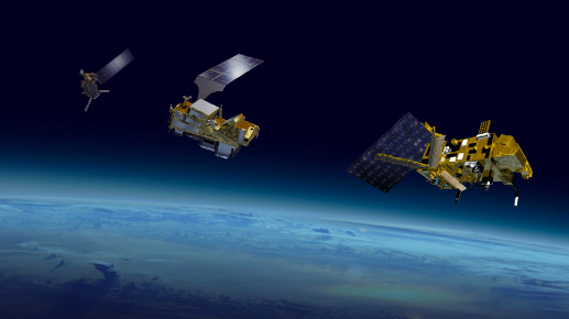
COSMIC-2
FormoSat-7 (Formosa Satellite 7) / COSMIC-2 (Constellation Observing System for Meteorology, Ionosphere and Climate)
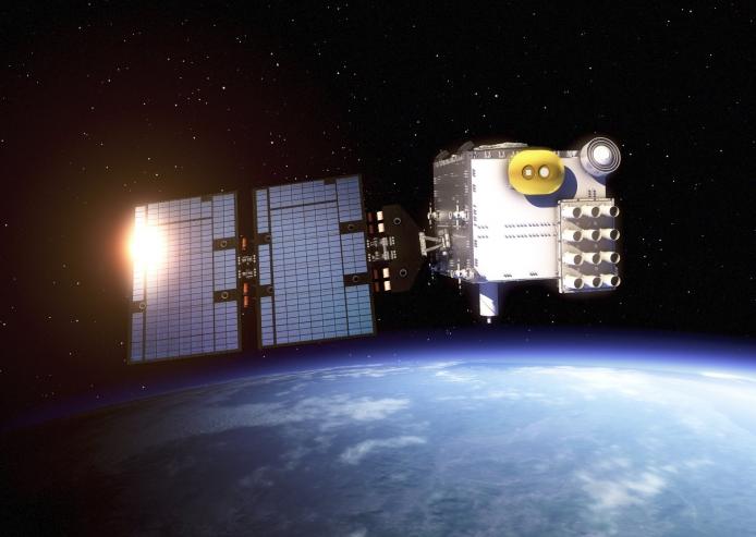 COSMIC-2 also known as FORMOSAT-7, is
the constellation of satellites for meteorology, ionosphere, climatology, and space weather research.
FORMOSAT-7 is a joint US-Taiwanese project including National Space Organization (NSPO) on the
Taiwanese side and the National Oceanic and Atmospheric Administration (NOAA) and the United States
Air Force (USAF) on the US side. FORMOSAT-7 is the successor of FORMOSAT-3. The six satellites of the
constellation were launched 25 June 2019 on a Falcon Heavy rocket. They reached their designated
mission orbits in February 2021, after eighteen months of gradual orbital adjustments.This team of
COSMIC satellites circles the equator at approximately 17,000 miles per hour and uses a technique
called radio occultation to collect information on our planet’s atmosphere. Here’s how it works:
Global Positioning System (GPS) satellites constantly send signals down to receivers on Earth, but
those signals get distorted along the way because the density of Earth’s atmosphere changes with
height. COSMIC-2 satellites can detect and measure any small bends in those signals before they are
cut off by Earth’s horizon. The three-minute period before the radio signal is cut off is known as
radio occultation, and that data are what gives scientists near real-time information about the
Earth’s atmosphere including conditions such as: temperature, pressure, density and water vapor.
COSMIC-2 also known as FORMOSAT-7, is
the constellation of satellites for meteorology, ionosphere, climatology, and space weather research.
FORMOSAT-7 is a joint US-Taiwanese project including National Space Organization (NSPO) on the
Taiwanese side and the National Oceanic and Atmospheric Administration (NOAA) and the United States
Air Force (USAF) on the US side. FORMOSAT-7 is the successor of FORMOSAT-3. The six satellites of the
constellation were launched 25 June 2019 on a Falcon Heavy rocket. They reached their designated
mission orbits in February 2021, after eighteen months of gradual orbital adjustments.This team of
COSMIC satellites circles the equator at approximately 17,000 miles per hour and uses a technique
called radio occultation to collect information on our planet’s atmosphere. Here’s how it works:
Global Positioning System (GPS) satellites constantly send signals down to receivers on Earth, but
those signals get distorted along the way because the density of Earth’s atmosphere changes with
height. COSMIC-2 satellites can detect and measure any small bends in those signals before they are
cut off by Earth’s horizon. The three-minute period before the radio signal is cut off is known as
radio occultation, and that data are what gives scientists near real-time information about the
Earth’s atmosphere including conditions such as: temperature, pressure, density and water vapor.
- Level 1b
- Atmospheric excess phase
- Level 2
- Atmospheric profiles
- Level 3
- The planetary boundary layer height
- Total Column Water Vapour
- Tropopause Height
- Documentations
- Release notes
- Level2 1D-var data (V1.0) has been released since January 31, 2023
- Level2 1D-var data (V3.2) has been released since November 1, 2023
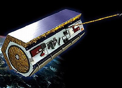
KOMPSAT5
The KOMPSAT-5 (Arirang-5) spacecraft was launched on August 22, 2013 on a Dnepr-1 launch vehicle of ISC Kosmotras from the Dombarovsky Launch Site, Yasny, Russia.
 The goal of the KOMPSAT 5 (Korean Multi-purpose Satellite 5) or Arirang 5 project is to lead the
development of the first Korean SAR Satellite using manpower and facilities from the KOMPSAT-3
program. It aims to support the national SAR (Synthetic Aperture Radar) satellite demand and form a
technology infrastructure to make inroads into the world space industry.
KOMPSAT-5, which was developed since in the middle of 2005, was launched in 2014 and its payload is a
X-band SAR a, which operates at Dawn-Dusk orbit between an altitude of 500 km to 600 km.
It executes all weather and all day observations of the Korean peninsula during its five year mission
using the SAR payload, unlike the optical KOMPSAT-1, -2 and -3 satellites. And in order to meet the
urgent national needs for various SAR image information, the KOMPSAT-5 GOLDEN Mission will provide GIS
(Geographical Information Systems), Ocean monitoring, Land management, Disaster monitoring, and
Environment monitoring.
The primary mission of the KOMPSAT-5 system is to provide high resolution mode SAR images of 1 meter
resolution, standard mode SAR images of 3 meter resolution and wide swath mode SAR images of 20 meter
resolution with viewing conditions of the incidence angle of 45 degrees using the COSI (COrea SAR
Instrument) payload, for meeting GOLDEN mission objectives.
The secondary mission of KOMPSAT-5 is to generate the atmospheric sounding profile and support radio
occultation science using AOPOD (atmospheric occultation and precision orbit determination) secondary
payload which is composed of a dual frequency GPS receiver and a laser retroreflector array (LRRA).
The goal of the KOMPSAT 5 (Korean Multi-purpose Satellite 5) or Arirang 5 project is to lead the
development of the first Korean SAR Satellite using manpower and facilities from the KOMPSAT-3
program. It aims to support the national SAR (Synthetic Aperture Radar) satellite demand and form a
technology infrastructure to make inroads into the world space industry.
KOMPSAT-5, which was developed since in the middle of 2005, was launched in 2014 and its payload is a
X-band SAR a, which operates at Dawn-Dusk orbit between an altitude of 500 km to 600 km.
It executes all weather and all day observations of the Korean peninsula during its five year mission
using the SAR payload, unlike the optical KOMPSAT-1, -2 and -3 satellites. And in order to meet the
urgent national needs for various SAR image information, the KOMPSAT-5 GOLDEN Mission will provide GIS
(Geographical Information Systems), Ocean monitoring, Land management, Disaster monitoring, and
Environment monitoring.
The primary mission of the KOMPSAT-5 system is to provide high resolution mode SAR images of 1 meter
resolution, standard mode SAR images of 3 meter resolution and wide swath mode SAR images of 20 meter
resolution with viewing conditions of the incidence angle of 45 degrees using the COSI (COrea SAR
Instrument) payload, for meeting GOLDEN mission objectives.
The secondary mission of KOMPSAT-5 is to generate the atmospheric sounding profile and support radio
occultation science using AOPOD (atmospheric occultation and precision orbit determination) secondary
payload which is composed of a dual frequency GPS receiver and a laser retroreflector array (LRRA).
- Level 1b
- Atmospheric excess phase
- Level 2
- Atmospheric profiles
- Level 3
- The planetary boundary layer height
- Total Column Water Vapour
- Tropopause Height
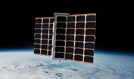
PAZ
PAZ was launched on 22 February 2018 from Vandenberg, Space Launch Complex 4
 Paz (Spanish for "Peace") is a Spanish Earth observation and reconnaissance satellite launched on 22
February 2018. It is Spain's first spy satellite.The satellite is operated by Hisdesat.Paz was
previously referred to as SEOSAR (Satélite Español de Observación SAR).
For observational purposes, Paz uses a synthetic aperture radar (SAR) to collect images of Earth for
governmental and commercial use, as well as other ship tracking and weather sensors, which enables
high-resolution mapping of large geographical areas at day and night. The X-band radar imaging payload
operates at a wavelength of 3.1 centimetres (1.2 in), or a frequency of 9.65 gigahertz.
The Paz satellite is operated in a constellation with the German SAR fleet TerraSAR-X and TanDEM-X on
the same orbit. The collaboration was agreed on by both Hisdesat and former European aerospace
manufacturer Astrium, operator of the two other satellites. The high-resolution images will be used
for military operations, border control, intelligence, environmental monitoring, protection of natural
resources, city, and infrastructure planning, and monitoring of natural catastrophes.
Originally, Paz was scheduled for launch from the Yasny launch base, Russia, in 2014, but this was
delayed due to Russia's 2014 annexation of Crimea, resulting in an International Court of Arbitration
legal battle between Hisdesat and Kosmotras. The US launch was estimated to cost around €53 million,
cost partially reduced by the inclusion of several mobile internet satellites on the same flight.
Paz (Spanish for "Peace") is a Spanish Earth observation and reconnaissance satellite launched on 22
February 2018. It is Spain's first spy satellite.The satellite is operated by Hisdesat.Paz was
previously referred to as SEOSAR (Satélite Español de Observación SAR).
For observational purposes, Paz uses a synthetic aperture radar (SAR) to collect images of Earth for
governmental and commercial use, as well as other ship tracking and weather sensors, which enables
high-resolution mapping of large geographical areas at day and night. The X-band radar imaging payload
operates at a wavelength of 3.1 centimetres (1.2 in), or a frequency of 9.65 gigahertz.
The Paz satellite is operated in a constellation with the German SAR fleet TerraSAR-X and TanDEM-X on
the same orbit. The collaboration was agreed on by both Hisdesat and former European aerospace
manufacturer Astrium, operator of the two other satellites. The high-resolution images will be used
for military operations, border control, intelligence, environmental monitoring, protection of natural
resources, city, and infrastructure planning, and monitoring of natural catastrophes.
Originally, Paz was scheduled for launch from the Yasny launch base, Russia, in 2014, but this was
delayed due to Russia's 2014 annexation of Crimea, resulting in an International Court of Arbitration
legal battle between Hisdesat and Kosmotras. The US launch was estimated to cost around €53 million,
cost partially reduced by the inclusion of several mobile internet satellites on the same flight.
- Level 1b
- Atmospheric excess phase
- Level 2
- Atmospheric profiles
- Level 3
- The planetary boundary layer height
- Total Column Water Vapour
- Tropopause Height
CHAMP
The Challenging Minisatellite Payload (CHAMP) launched July 15, 2000 from Plesetsk, Russia
 CHAMP (CHAllenging Minisatellite Payload) is a German small satellite mission for geoscientific and
atmospheric research and applications, managed by GeoForschungsZentrum (GFZ). The payload includes an
accelerometer, magnetometers, a GPS receiver, a laser retro reflector, and an ion drift meter. With
its orbit characteristics (near polar, low altitude, long duration) CHAMP will generate for the first
time simultaneously highly precise gravity and magnetic field measurements over a 5 years period. This
will allow to detect besides the spatial variations of both fields also their variability with time.
In addition CHAMP is a pilot mission for the pre-operational use of space-borne GPS observations for
atmospheric and ionospheric research and applications in weather prediction and space weather
monitoring. The 500 kg, triaxially stabilized spacecraft was launched by a Kosmos-3M rocket from
Plesetsk at 12:00 UT, along with two other satellites.
CHAMP (CHAllenging Minisatellite Payload) is a German small satellite mission for geoscientific and
atmospheric research and applications, managed by GeoForschungsZentrum (GFZ). The payload includes an
accelerometer, magnetometers, a GPS receiver, a laser retro reflector, and an ion drift meter. With
its orbit characteristics (near polar, low altitude, long duration) CHAMP will generate for the first
time simultaneously highly precise gravity and magnetic field measurements over a 5 years period. This
will allow to detect besides the spatial variations of both fields also their variability with time.
In addition CHAMP is a pilot mission for the pre-operational use of space-borne GPS observations for
atmospheric and ionospheric research and applications in weather prediction and space weather
monitoring. The 500 kg, triaxially stabilized spacecraft was launched by a Kosmos-3M rocket from
Plesetsk at 12:00 UT, along with two other satellites.
- Level 1b
- Atmospheric excess phase
- Level 2
- Atmospheric profiles
- Level 3
- The planetary boundary layer height
- Total Column Water Vapour
- Tropopause Height
Spire
Spire Global Nanosatellite Constellation
 In 2014, commercial company Spire Global inaugurated the Lemur project with the launch of the Low Earth Multi-Use Receiver-1 (Lemur-1) prototype satellite on a Soyuz Rocket. The main objective of the mission was to demonstrate the satellite platform and support systems. Lemur-2 is a constellation of nano-satellites with 3U CubeSat platforms, designed to maintain up to 175 flight units. The program began in 2015 with the launch of four Lemur-2 nanosatellites, and a total of 156 flight units have been launched as of May 2022. Lemur-2 images are used to track maritime, aviation, and weather activity from space.
- Level 1b
- Atmospheric excess phase
- Level 2
- Atmospheric profiles
- Level 3
- The planetary boundary layer height
- Total Column Water Vapour
- Tropopause Height
COSMIC-1
FormoSat-3 (Formosa Satellite 3) / COSMIC-1 (Constellation Observing System for Meteorology, Ionosphere and Climate)
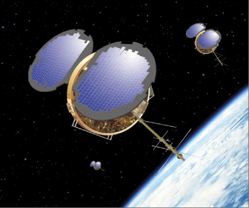 The FormoSat-3/COSMIC-1 (Formosa Satellite 3 / Constellation Observing System for Meteorology, Ionosphere and Climate), is an international collaborative project between NSPO (National Space Program Office) of Taiwan and UCAR (University Corporation for Atmospheric Research) of the United States of America. Initiated in December 1997, the project will launch a LEO constellation of six microsatellites to collect atmospheric remote sensing data for operational weather prediction, climate, ionospheric (space weather monitoring), and geodesy research. NSPO is the prime sponsor and owner of the satellites. UCAR, located at NCAR in Boulder, CO, is primarily sponsored by NSF (National Science Foundation). Other partners in the project include JPL, NRL, USAF, NOAA, CWB (Central Weather Bureau of Taiwan), industry from both countries, universities, and other research organizations from the US, Taiwan, and other countries.
The overall objective of FormoSat-3/COSMIC-1 is to extend the low-cost research approach of refractive GPS radio occultation measurements (to derive important weather and climate research parameters, including atmospheric temperature, moisture, and pressure), that began with the GPS/MET instrument on Microlab-1 (launch April 3, 1995), to the next step by testing the ability of a constellation of six "ROCSat-3/COSMIC microsatellites with GPS/MET heritage" to provide the data needed to fully evaluate the impact of this promising new observational tool.
A goal is also to demonstrate the utility of atmospheric/ionospheric limb soundings in operational weather prediction, space weather monitoring and space geodesy. In addition to carrying an advanced version of the JPL-developed GPS receiver for occultation measurement, each satellite will carry two tiny, simple secondary instruments (tri-band-beacon and photometer) which synergistically enhance the accuracy and utility of the ionospheric observations. A global data collection network and operations center will process space and ground observations and deliver products to users in real-time for operational impact studies.
The FormoSat-3/COSMIC-1 (Formosa Satellite 3 / Constellation Observing System for Meteorology, Ionosphere and Climate), is an international collaborative project between NSPO (National Space Program Office) of Taiwan and UCAR (University Corporation for Atmospheric Research) of the United States of America. Initiated in December 1997, the project will launch a LEO constellation of six microsatellites to collect atmospheric remote sensing data for operational weather prediction, climate, ionospheric (space weather monitoring), and geodesy research. NSPO is the prime sponsor and owner of the satellites. UCAR, located at NCAR in Boulder, CO, is primarily sponsored by NSF (National Science Foundation). Other partners in the project include JPL, NRL, USAF, NOAA, CWB (Central Weather Bureau of Taiwan), industry from both countries, universities, and other research organizations from the US, Taiwan, and other countries.
The overall objective of FormoSat-3/COSMIC-1 is to extend the low-cost research approach of refractive GPS radio occultation measurements (to derive important weather and climate research parameters, including atmospheric temperature, moisture, and pressure), that began with the GPS/MET instrument on Microlab-1 (launch April 3, 1995), to the next step by testing the ability of a constellation of six "ROCSat-3/COSMIC microsatellites with GPS/MET heritage" to provide the data needed to fully evaluate the impact of this promising new observational tool.
A goal is also to demonstrate the utility of atmospheric/ionospheric limb soundings in operational weather prediction, space weather monitoring and space geodesy. In addition to carrying an advanced version of the JPL-developed GPS receiver for occultation measurement, each satellite will carry two tiny, simple secondary instruments (tri-band-beacon and photometer) which synergistically enhance the accuracy and utility of the ionospheric observations. A global data collection network and operations center will process space and ground observations and deliver products to users in real-time for operational impact studies.
- Level 1b
- Atmospheric excess phase
- Level 2
- Atmospheric profiles
- Level 3
- The planetary boundary layer height
- Total Column Water Vapour
- Tropopause Height
GRAS
MetOp (Meteorological Operational Satellite Program of Europe)
 The Meteorological Operational satellite program (MetOp) is a collaboration between the European Space Agency (ESA) and the European Organisation for the Exploitation of Meteorological Satellites (EUMETSAT) with the aim to provide satellite observation and data services for weather prediction and climate monitoring. MetOp provides temperature and humidity profiles on the atmosphere, as well as wind speed and direction above the ocean data for Numerical Weather Prediction (NWP). MetOp-A, launched in 2006 and retired in 2021, began the MetOp series, followed by the launches of MetOp-B and -C in 2012 and 2018, respectively.
The MetOp satellites are identical in design, each carrying 11 instruments which provide data for weather predictions. Infrared Atmospheric Sounding Interferometer (IASI) measures infrared radiation emitted from Earth’s surface to derive data on humidity and atmospheric temperature profiles in the troposphere and lower stratosphere. Microwave Humidity Sounder (MHS) measures microwave radiation emitted from Earth’s surface to acquire measurements at various altitudes of atmospheric humidity, including rain, snow, hail, sleet, and temperature. Global Navigation Satellite System Receiver for Atmospheric Sounding (GRAS) operates as an atmospheric-sounding instrument that supplies atmospheric soundings of the temperature and humidity of the Earth’s atmosphere.
Advanced Scatterometer (ASCAT) measures wind speed and direction over the ocean. Global Ozone Monitoring Experiment-2 (GOME-2) is a spectrometer that collects light arriving from the Sun-illuminated Earth’s atmosphere or a direct view to the Sun and decomposes it into its spectral components to derive a detailed picture of the atmospheric content and profile of certain atmospheric components. Advanced Microwave Sounding Units (AMSU-A1 and AMSU-A2) measure scene radiance in the microwave spectrum. High Resolutions Infrared Radiation Sounder (HIRS/4) is a 20-channel radiometric sounder measuring radiance in the infrared spectrum. Data from the AMSU instruments and HIRS/4 are used in conjunction to calculate the global atmospheric temperature and humidity profiles from the Earth’s surface to the upper stratosphere as well as provide precipitation and surface measurement. Advanced Very High Resolutions Radiometer (AVHRR/3) provides day and night imaging of land, water and clouds and measures sea surface temperature, ice, snow, and vegetation cover. Space Environment Monitor (SEM-2) is a spectrometer that provides measurements to determine the intensity of the Earth’s radiation belts and the flux of charged particles at the satellite altitude.
The Meteorological Operational satellite program (MetOp) is a collaboration between the European Space Agency (ESA) and the European Organisation for the Exploitation of Meteorological Satellites (EUMETSAT) with the aim to provide satellite observation and data services for weather prediction and climate monitoring. MetOp provides temperature and humidity profiles on the atmosphere, as well as wind speed and direction above the ocean data for Numerical Weather Prediction (NWP). MetOp-A, launched in 2006 and retired in 2021, began the MetOp series, followed by the launches of MetOp-B and -C in 2012 and 2018, respectively.
The MetOp satellites are identical in design, each carrying 11 instruments which provide data for weather predictions. Infrared Atmospheric Sounding Interferometer (IASI) measures infrared radiation emitted from Earth’s surface to derive data on humidity and atmospheric temperature profiles in the troposphere and lower stratosphere. Microwave Humidity Sounder (MHS) measures microwave radiation emitted from Earth’s surface to acquire measurements at various altitudes of atmospheric humidity, including rain, snow, hail, sleet, and temperature. Global Navigation Satellite System Receiver for Atmospheric Sounding (GRAS) operates as an atmospheric-sounding instrument that supplies atmospheric soundings of the temperature and humidity of the Earth’s atmosphere.
Advanced Scatterometer (ASCAT) measures wind speed and direction over the ocean. Global Ozone Monitoring Experiment-2 (GOME-2) is a spectrometer that collects light arriving from the Sun-illuminated Earth’s atmosphere or a direct view to the Sun and decomposes it into its spectral components to derive a detailed picture of the atmospheric content and profile of certain atmospheric components. Advanced Microwave Sounding Units (AMSU-A1 and AMSU-A2) measure scene radiance in the microwave spectrum. High Resolutions Infrared Radiation Sounder (HIRS/4) is a 20-channel radiometric sounder measuring radiance in the infrared spectrum. Data from the AMSU instruments and HIRS/4 are used in conjunction to calculate the global atmospheric temperature and humidity profiles from the Earth’s surface to the upper stratosphere as well as provide precipitation and surface measurement. Advanced Very High Resolutions Radiometer (AVHRR/3) provides day and night imaging of land, water and clouds and measures sea surface temperature, ice, snow, and vegetation cover. Space Environment Monitor (SEM-2) is a spectrometer that provides measurements to determine the intensity of the Earth’s radiation belts and the flux of charged particles at the satellite altitude.
- Level 1b
- Atmospheric excess phase
- Level 2
- Atmospheric profiles
- Level 3
- The planetary boundary layer height
- Total Column Water Vapour
- Tropopause Height
TOR
TDX (TanDEM-X)
 TanDEM-X is an interferometric SAR satellite mission, funded in a public/private collaboration between the German Aerospace Centre (DLR) and Airbus Defence and Space (formerly EADS Astrium GmbH). The satellite launched in June, 2010 and constructs three-dimensional images of Earth’s surface.
TanDEM-X is identical to its twin, TerraSAR-X, and has one X-band Synthetic Aperture Radar that collects high-resolution images for the monitoring of land surfaces and coastal processes, specifically for agricultural, geological, and hydrological applications. The sensor measures a multitude of processes including Albedo and reflectance, landscape topography, multi-purpose imagery of land and ocean, ocean topography and currents, sea ice cover, edge and thickness, snow cover, edge and depth, and vegetation.
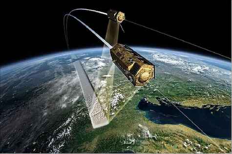
TanDEM-X also includes a Tracking, Occultation and Ranging (TOR) payload that consists of a dual-frequency Integrated GPS Occultation Receiver (IGOR) functioning as an independent tracking technique via the Laser Retro Reflector (LRR). There is also a Laser Communications Terminal (LCT) that demonstrates an optical link that is a part of an experimental broadband data relay transmitting 300 Mbit/s from TanDEM-X to the ground segment.
TanDEM-X is an interferometric SAR satellite mission, funded in a public/private collaboration between the German Aerospace Centre (DLR) and Airbus Defence and Space (formerly EADS Astrium GmbH). The satellite launched in June, 2010 and constructs three-dimensional images of Earth’s surface.
TanDEM-X is identical to its twin, TerraSAR-X, and has one X-band Synthetic Aperture Radar that collects high-resolution images for the monitoring of land surfaces and coastal processes, specifically for agricultural, geological, and hydrological applications. The sensor measures a multitude of processes including Albedo and reflectance, landscape topography, multi-purpose imagery of land and ocean, ocean topography and currents, sea ice cover, edge and thickness, snow cover, edge and depth, and vegetation.
TanDEM-X also includes a Tracking, Occultation and Ranging (TOR) payload that consists of a dual-frequency Integrated GPS Occultation Receiver (IGOR) functioning as an independent tracking technique via the Laser Retro Reflector (LRR). There is also a Laser Communications Terminal (LCT) that demonstrates an optical link that is a part of an experimental broadband data relay transmitting 300 Mbit/s from TanDEM-X to the ground segment.
- Level 1b
- Atmospheric excess phase
- Level 2
- Atmospheric profiles
- Level 3
- The planetary boundary layer height
- Total Column Water Vapour
- Tropopause Height

Option 1: Access Data from HTTP server
| RO mission | STAR ROPP atmPrf Data on HTTP server | STAR ROPP atmPrf ICVS Monitoring & Doc | STAR 1Dvar wetPrf Data on HTTP server | STAR 1Dvar wetPrf ICVS Monitoring & Doc |
|---|---|---|---|---|
| COSMIC-2 | Near Real Time Post-Processing |
ICVS Monitoring ATBD |
Near Real Time Post-Processing |
ICVS Monitoring ATBD |
| COSMIC-1 | Post-Processing |
ICVS Monitoring ATBD |
Post-Processing |
ICVS Monitoring ATBD |
| Spire | Post-Processing |
ICVS Monitoring ATBD |
Post-Processing |
ICVS Monitoring ATBD |
| GRAS Metop-A | Post-Processing |
ICVS Monitoring ATBD |
Post-Processing |
ICVS Monitoring ATBD |
| GRAS Metop-B | Near Real Time Post-Processing |
ICVS Monitoring ATBD |
Near Real Time Post-Processing |
ICVS Monitoring ATBD |
| GRAS Metop-C | Near Real Time Post-Processing |
ICVS Monitoring ATBD |
Near Real Time Post-Processing |
ICVS Monitoring ATBD |
| KOMPSAT-5 | Near Real Time Post-Processing |
ICVS Monitoring ATBD |
Near Real Time Post-Processing |
ICVS Monitoring ATBD |
| PAZ | Near Real Time Post-Processing |
ICVS Monitoring ATBD |
Near Real Time Post-Processing |
ICVS Monitoring ATBD |
Option 2: Access Data from FTP server
ftp starro.umd.edu
username: anonymous
cd starro/data/
## The directory structure is the same as on the HTTP server in option 1